Wednesday, October 31, 2007
Noel still heading west. Wild Weather Wednesday
Wild Weather Wednesday
The 2005 Hurricane season.
In 2005 we had a record breaking season. We had 27 Storms 13 of them tropical storms and 15 Hurricanes. We also had hurricane Wilma which had the lowest Pressure on record. 5 hurricane made landfall and 3 tropical storms made landfall. Thank you for visting on Wild Weather Wednesday.
H10
Tuesday, October 30, 2007
Update on Noel
H10
Monday, October 29, 2007
Quick post on our new tropical storm Noel
H10
Friday, October 26, 2007
New system to watch 90L
90L is located about 88 miles SW of San Juan, Puerto Rico with winds up to 25 knots. 90L continues to look not very impressive as seen on the latest satellite imagery. If you look close enough you can see the COC just SW of Puerto Rico. 90L is expected to continue its westward movement into the western Caribbean. It is to early to tell what will happen with 90L. I will have an update on 90L Monday unless it develops.
H10
Wednesday, October 24, 2007
Wild Weather Wednesdays.
Tuesday, October 23, 2007
One area of disturbed weather. And a new series Wild Weather Wednesday
Wild Weather Wednesday.
I am starting a new series called Wild Weather Wednesday. I will have a new topic every week, stay tuned this wednesday on the C.A. wildfires.
H10
Monday, October 22, 2007
Not much going on in the Atlantic as hurricane season comes to a close
For Hurricane Tracker I am Hurricane 10
Thursday, October 18, 2007
Not much going on in the tropics.
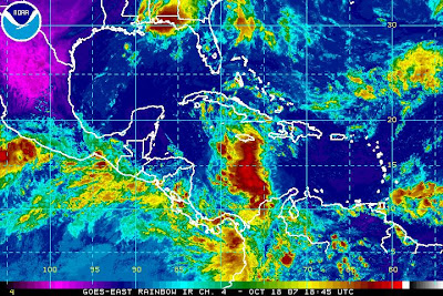
For Hurricane Tracker I am Hurricane 10
Monday, October 15, 2007
Two new disturbances to watch 98L and 99L
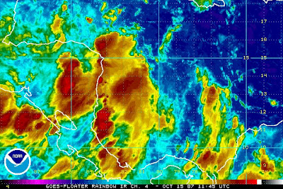
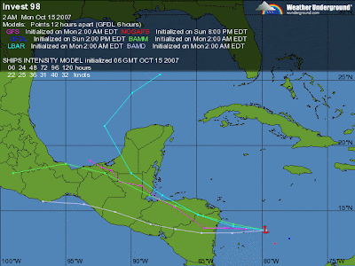 Figure 2. 98L latest computer models.
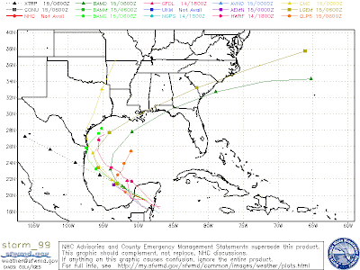
99L
99L is also not looking very organized but is only under 5-10 knots of shear which may allow some slow development. I might have an update on 99L later today. here is the latest computer models for 99L.
Friday, October 12, 2007
TD 15
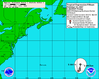
For Hurricane Tracher I am Hurricane10
Wednesday, October 10, 2007
94L comes ashore
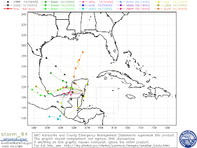
For Hurricane Tracker I am Hurricane10
Tuesday, October 9, 2007
Tropical depression may form today.
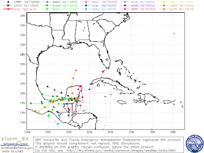
For Hurricane Tracker I am Hurricane10
Friday, October 5, 2007
92L getting its act together. 91L taking a beating

Figure 1. Satellite picture of 92L and located on the bottom right is 91L.
91L
91L continues to be battered by 20-40 knots of wind shear. 91L also continues to generate a lot of heavy thunderstorms. We will have to see what will happen with 91L.
I might not get a post up Saturday but i will have one up by Sunday at 5pm.
66666For my earlier post today please scroll down 66666
For Hurricane Tracker I'm Hurricane10
update on 91L,92L, and Super Typhoon Krosa
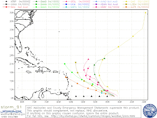
91L continues to remain disorganized today on resent satellite loops. It is being tore up by wind shear up to 20-30 knots.This may kill off the storm but it is to early to tell what will happen. If the storm does survive most of the computer models bring to the Lesser Antilles and the a more northerly curve towards puerto rico. Here are the computer models for 91L.
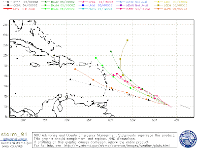
Since yesterday you can see that most of the computer models are bringing it more south. we will have to see what happens with 91L. I might have an update on 91L later today.
92L---sorry i am having technical difficulties with 92L but i will have an update on 91L later today.---
Super Typhoon Krosa
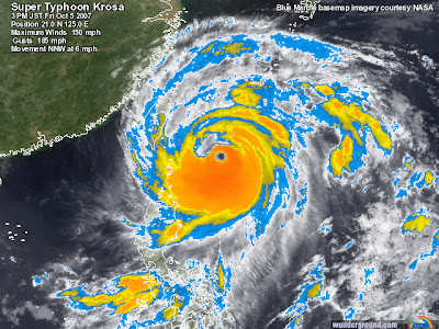
Krosa continues to look very impressive on satellite imagery. Krosa has winds of 150mph and gust up to 185mph. She is expected to hit north Taiwan. Here is the latest satellite imagery.
For Hurricane Tracker I'm Hurricane10
Thursday, October 4, 2007
90L Not a threat. Update on 91L,92L, and Typhoon Krosa

I will have an update on 92L later today.
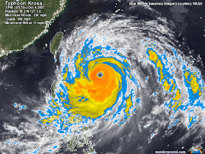
Typhoon Krosa
Max sustained winds: 130mph gusts up to 160 mph. location: western pacific.
For Hurricane Tracker I'm Hurricane10
Wednesday, October 3, 2007
busy
sorry
im hurricane 10
Tuesday, October 2, 2007
90L getting better organized.
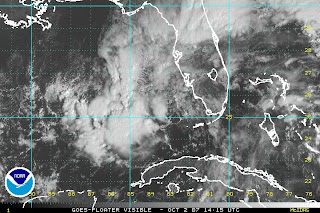 Most of the computer models bring 90L to Texas or Louisiana as a tropical storm.This storm will likely start out as a subtropical depression instead of a normal tropical depression.(subtropical means it does not have all the tropical characteristics as it should).
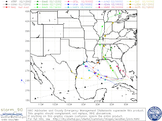 This is the computer models for 90L. As you can see most of the models take 90L to Galveston bay or the FL/AL border. If you have any questions please leave me a comment.
Abbreviations for tropical talk.
CATL: Central Atlantic
CDO: Central Dense Overcast
CMC: Canadian Meteorological Center
EATL: East Atlantic
ECMWF: European Center for Medium range WeatherForecasting
GFDL: Geophysical Fluid Dynamics Laboratory
GFS: Global Forecast System
GOMEX: Gulf Of MEXico
HWRF: Hurricane and Weather Research Forecasting
IVO: In the Vicinity Of
LLC: Low Level Circulation
MJO: Madden Julian Oscillation
MSLP: Mean Sea Level Pressure
NAM: North American Model
NCATL: North Central Atlantic
NEWD: Northeastward
NHC: National Hurricane Center
NOGAPS: Navy Operational Global Atmospheric PredictionSystem
NWD: Northward
OBX: Outer Banks (N.C.)
SEUS: SouthEast U.S.
SWWD: Southwestward
TUTT: Tropical Upper Tropospheric Trof
UKMET: United Kingdom METeorological office
ULL: Upper Level Low
UTC: Universal Time Coordinated
WW3: WaveWatch 3
modelZulu Time: (Z) as in 1200Z...Same as UTC.
thank you for hurricne tracker im hurricane10
ill have an update in about an hour.
Monday, October 1, 2007
Update on 90L
8:00 model run. Only four models the BAMM, BAMD, BAMS, and the UKMET ran for 9oL. I will break each model down.
1. BAMM. Shows 90L scraping panama city beach.
2.BAMS. Same as BAMM
3.BAMS. Shows 90L hitting the MI/AL border
4.UKMET. Shows 90L hitting about 100 miles east of New Orleans.
For HURRICANE TRACKER I'm Hurricane10
8:20pm
New system to watch 90L.Karen and Melissa gone.
1. This system located around south Florida was labeled "invest 90L" by the NHC earlier today. The newest satellite loops show obvious rotation around south Florida and people anywhere from the Florida panhandle to the Texas/Mexico border
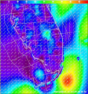
figure 1. This picture is a wind analysis From south Florida. As you can see just off the coast of the Florida keys is winds up to 50 knots witch is about 57 mph.
2. Karen and Melissa. Karen was torn up by wind shear up to 50 knots Saturday and could possible redevelop within the next couple of days. I give this about a 50% chance of happening. Melissa was also torn apart by wind shear and will probable not redevelop.
For Hurricane Tracker I'm Hurricane 10

